100 Products That Changed the World · #19: Google Maps
If you traveled before 2005, you likely remember the ritual:
You sat in front of a desktop computer, opened MapQuest or Yahoo Maps, typed in your origin and destination, and clicked submit. The browser flickered into a blank white screen for two or three seconds before reloading with a dense, printed itinerary—“Take Route 101 North for 3.2 miles, then turn right at Exit 4.” You printed those pages on paper, clipped them to your dashboard, and if you missed an exit on a multi-tiered interchange, the entire printout became useless. You pulled over to the shoulder and unfolded a creased paper highway map.
On February 8, 2005, when Google Maps launched, a subtle interaction detail fundamentally altered the history of the web:
You clicked and dragged the map to the left, and the entire landscape slid smoothly across your screen. The missing neighborhoods along the edges filled in seamlessly, like tiles laid down by an invisible hand—no white flash, no page reload, no waiting.
From that instant, the physiological anxiety of “getting lost,” a fixture of human existence for millennia, began to systematically vanish across a generation.
Larry Page’s mandate: from C++ desktop software to a web breakthrough
The catalyst that reshaped navigation was not born in Google’s Mountain View labs, but in a four-person startup in Sydney, Australia.
In early 2003, Danish brothers Lars and Jens Rasmussen, alongside Noel Gordon and Stephen Ma, founded Where 2 Technologies.
Frustrated by the clunky, page-by-page reloading of MapQuest, they initially set out to build a responsive C++ desktop application that users would download and install locally on their PCs.
Yet when pitching their software to Silicon Valley firms, they were turned down everywhere—until late summer 2004, when they demonstrated their prototype to Larry Page and Sergey Brin.
Page took one look at the fluid interface and issued an audacious counter-demand: “Don’t build a desktop app. Put it inside the browser, and never let the user experience a page refresh when dragging.”
In 2004, veteran engineers considered this nearly impossible. Web browsers were still essentially document viewers designed for static text and hyperlinks; any heavy JavaScript routines routinely froze the browser tab.
Page, however, understood network distribution: if users had to download and configure software, maps would remain a niche tool for tech enthusiasts. If accessible instantly in any browser via a simple URL, it could become universal public infrastructure for billions of people.
In October 2004, Google acquired Where 2 Technologies. In rapid succession, Google also snapped up two complementary companies: Keyhole, a 3D satellite imagery company backed by In-Q-Tel (the foundation of Google Earth), and ZipDash, a pioneer in real-time traffic sensor analysis.
The pieces converged rapidly in Mountain View, with Bret Taylor appointed as Google Maps’ founding product manager (he would later serve as CTO of Facebook, co-CEO of Salesforce, and Chairman of OpenAI).
Map tiles and AJAX: waking up Silicon Valley to the modern web
Between 1995 and 2005, web development was constrained by a single architectural dogma: the client requested a URL, the server generated full HTML, and the browser repainted the entire screen.
Google Maps achieved its seamless fluidity through two architectural breakthroughs:
First, the pyramid tile system (Map Tiles). Google sliced the Earth’s surface into hundreds of millions of 256×256 pixel image squares, organized into a quadtree pyramid across discrete zoom levels. When dragging the viewport, the browser did not render the globe; it simply calculated bounding coordinates and fetched only the dozen or so tiles visible within the screen frame.
Second, asynchronous JavaScript background requests (formally named AJAX). Using hidden background network objects, the browser fetched adjacent tiles silently while the user was interacting, preloading them into local memory before they even entered the visible viewport.
Weeks after Google Maps launched on February 8, 2005, Jesse James Garrett published the seminal essay “AJAX: A New Approach to Web Applications”, citing Google Maps as its ultimate proof of concept.
It startled Silicon Valley into a collective realization: the web browser was no longer merely a digital printing press for documents—it was a full-fledged, high-performance operating system for software applications.
Modern web tools we rely on daily—Google Docs, Figma, Notion—trace their foundational engineering lineage to that single draggable map in 2005.
Street View: turning software into physical heavy industry
Most software companies operate on the premise of near-zero marginal distribution costs. Google Maps, however, took a radical turn into an operational domain that terrified traditional software companies: it transformed itself into a capital-intensive, heavy-duty surveying enterprise.
In May 2007, Google introduced Street View.
It began with Larry Page and a handful of engineers strapping commercial DSLR cameras to the roof of a Chevrolet van, cruising through San Francisco to snap panoramas. It swiftly evolved into the most extensive global surface-mapping endeavor in commercial history:
Google deployed customized automotive fleets equipped with LiDAR scanners and 15-lens panoramic rigs, modified Street View gondolas to map the canals of Venice, built 40-pound wearable backpacks (Trekker) to hike the Grand Canyon and polar frontiers, and even mounted cameras onto camels to traverse the Arabian Desert.
To date, the Street View fleet has traveled over 16 million kilometers—equivalent to circling the equator more than 400 times—capturing more than 220 billion panoramic images spanning over 100 countries and territories.
This multi-billion-dollar ground truth constitutes one of the deepest operational moats in the history of the internet.
Its durability was demonstrated decisively in 2012:
In an effort to reduce dependence on its primary rival, Apple abruptly dropped Google Maps as the default navigation engine in iOS 6, rushing out its proprietary Apple Maps. The result was an immediate operational debacle: the Brooklyn Bridge appeared grotesquely melted in 3D views, train stations were placed in the middle of rivers, and airports were mislocated in remote Australian outbacks. Tim Cook issued a public apology, explicitly suggesting that iPhone users download Google Maps or use competing web maps while Apple rebuilt its system.
The crisis drove home an inescapable reality: the barrier to digital mapping is not software algorithms or vector graphics engines—it is the painstaking, capital-heavy accumulation of physical truth gathered meter by meter on the ground.
The ambient sensor: digital substrate of the modern economy
When Steve Jobs unveiled the original iPhone in 2007, he opened Google Maps on stage, searched for a nearby Starbucks, and casually placed a prank order for 4,000 caffe lattes.
Once GPS chips became standard in smartphones by 2008, digital mapping underwent another evolutionary leap:
It was no longer a static atlas consulted before leaving home. It became an ambient spatial radar, continuously tracking your precise physical coordinates and reading the pulse of traffic around you.
In 2009, Google made turn-by-turn navigation free on Android, wiping out the standalone hardware market dominated by Garmin and TomTom.
More fundamentally, it laid the foundation for the multi-trillion-dollar mobile economy:
- Without high-frequency geospatial routing APIs, Uber, Lyft, and Grab could not dispatch drivers algorithmically;
- Without meter-accurate street networks and reverse geocoding, instant on-demand delivery platforms like DoorDash and Meituan would grind to a halt;
- Without verified merchant hours, user reviews, and live foot-traffic histograms, the discovery of local commerce across thousands of cities would collapse.
Humanity stopped getting lost. The quiet tradeoff is that we surrendered our innate sense of spatial orientation to an omnipresent blue pulsating dot.
Why it ranks
| Dimension | Score | Rationale |
|---|---|---|
| Originality ORG | 88 | Map tiles and asynchronous loading established modern rich web UX; digital cartography itself was not invented by Google |
| Scale SCL | 96 | Top-tier global scale. Over 1 billion monthly active users across 220 countries, serving as essential infrastructure across billions of devices |
| Impact IMP | 93 | Erased spatial disorientation from everyday modern life; enabled the multi-trillion-dollar gig and on-demand mobility economy |
| UX EXP | 93 | Seamless pan and zoom, accurate real-time colored traffic flows, immersive Street View, and Live View AR pedestrian navigation |
| Business BIZ | 88 | Highly restrained direct monetization via local ads and Places API; functions primarily as an ecosystem moat rather than an aggressive cash engine |
| Durability DUR | 95 | Active and indispensable for 21 years since 2005, navigating through PC, mobile, and spatial computing eras without disruption |
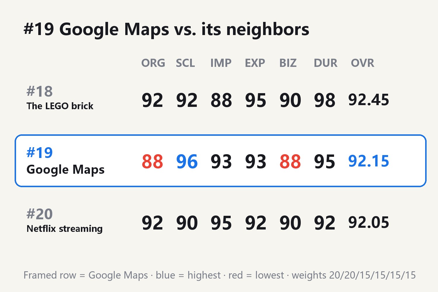
Overall OVR 92.15, ranked #19.
Why it lost points
Of the six dimensions, Google Maps received two relatively modest scores of 88, which reveal the core strategic reality of the product:
-
Originality (88): Electronic cartography was not invented by Google. MapQuest emerged in 1996, in-car GPS hardware proliferated in the late 1990s, and satellite viewing was inherited through the acquisition of Keyhole. Google’s innovation lay in reinventing interaction via dynamic slicing, and re-architecting data fidelity via unprecedented physical surveying.
-
Business (88): Compared to Google Search’s immense advertising cash flow or YouTube’s aggressive monetization, Google Maps has remained deliberately restrained. While Promoted Pins and enterprise Google Maps Platform APIs generate billions in high-margin revenue, they pale in comparison to the immense capital expenditures required to maintain camera fleets, purchase satellite imagery, and process spatial compute. Its primary objective is platform lock-in and real-world indexing, with monetization treated as a secondary priority.
Comparison with neighbors
It sits just behind #18 The LEGO brick (92.45), trailing by 0.30 points. The LEGO brick earned an unprecedented 98 durability and 95 tactile UX score by virtue of micro-metric manufacturing tolerances that remain backwards-compatible across 68 continuous years. While Google Maps commands greater global reach (96 vs. 92) and societal impact (93 vs. 88), LEGO’s near-permanent industrial design standards anchor it slightly higher.
It edges out #20 Netflix streaming (92.05) by 0.10 points. Netflix upended global media distribution through bingeable season drops and pure ad-free subscriptions, scoring higher in originality (92) and media impact (95). Yet Netflix remains fundamentally a cultural distribution pipeline, whereas Google Maps has integrated itself into the physical operating mechanics of human civilization. Superior scale (96 vs. 90) and historical longevity (95 vs. 92) secure Google Maps’ position.
Whether you find yourself in an unfamiliar alleyway in Tokyo, Paris, or Nairobi, pulling out your phone allows a single pulsating blue dot to confirm exactly where you stand on Earth and where to turn next. For the first time in human history, collective spatial security has been fully entrusted to a digital tapestry woven from code and physical wheels.
All scores and rankings in this article were generated by Claude (AI).
Cover image is an original infographic illustrating digital map tiles, arterial road networks, and geospatial pin architecture, containing no official Google trademarks.
Factual citations: Where 2 Technologies founded in 2003 by Lars and Jens Rasmussen, Noel Gordon, and Stephen Ma; Google acquired Where 2, Keyhole, and ZipDash in October 2004; Google Maps launched on February 8, 2005; Bret Taylor served as initial product manager; Jesse James Garrett coined AJAX in 2005 citing Google Maps as a prime example; Street View launched in May 2007; fleet logged over 16 million km and 220 billion panoramas; free turn-by-turn mobile navigation introduced in 2009; Apple Maps launch crisis and Tim Cook apology in 2012; historical archives of Google, IEEE Computer Society, and Encyclopaedia Britannica. Rankings evaluate products strictly across product dimensions.
Discussion